How the commercialization of satellite imagery has become for-profit domestic spying
In the early days of satellite imagery, its primary uses were global observation. The technology was owned by government agencies and motivated by reconnaissance, but later found use amongst scientists, educators, and humanitarian groups as well. Monitoring disaster relief efforts, refugee movements, environmental degradation, and international disputes became much more effective. Whether or not more uses were in want, the data was sparse and the technology too coarse to dive further anyway.
But privatization driven the industry towards commercial uses. More satellites than ever are setting their sights on the world, taking millions of images at no discretion. According to 2017 data, one-third of the 1,738 active satellites currently orbiting Earth are for the purpose of obtaining planetary imagery. Half of them are owned by commercial firms like DigitalGlobe and Planet. New commercial satellites have imaging capabilities approaching those of military spy satellites, but commercial satellites possess one key difference: their operators will sell the images to anyone, and there is a lot of money to be made.
The planet’s surface is a rich seam of data ready to be mined. Like all data, satellite imagery is in itself neutral until applied, and it is being increasingly utilized for profit. Businesses and governments have discovered the imagery’s value in tracking economic activity and the flow of human capital. This is shifting Earth observation inwards—from global protection to domestic spying—where nations have financial incentives to use satellites to monitor their citizens and corporations their consumers and competitors.
In 2000, federal regulators gave geospatial-imaging juggernaut DigitalGlobe permission to sell pictures at 50-centimeter resolution, and in April 2014, they were cleared to sell them at 31-centimeters—non-U.S. customers included. That will allow purchasers to go from being able to identify a car to being able to identify its make. The government’s inclination towards commercial interests over its own national sovereignty may shed light on how it overlooks privacy of its citizens. When our lawmakers surrender control of domestic territories to remote sensing, are they also forfeiting each individual’s right to privacy?
The race to rule the skies
To understand the standards under which satellites and imagery distribution operate today, it is important to look back at the history of the industry’s regulations, beginning with two founding policies set in place by the United Nations. The first was the 1967 Outer Space Treaty—which declared that outer space cannot be claimed as national territory—legitimized satellite travel by any country over any point on Earth. The second, ruled by the UN General Assembly in 1986, denied the right of prior consent for nations to review and possibly withhold data about their territories. These policies meant that under international law, countries have no grounds for objecting to being imaged from space, but have the right to access those images “on a nondiscriminatory basis and on reasonable cost terms”—or, for a price.
So began the international race to rule the business of remote sensing technologies. In the U.S., the value of satellite imagery was pulled between conflicting interests of commodification and self-defense. When should satellite imagery be treated as a public good under the government’s provision, and when should it be treated as a private good to be sold for financial gain? Economic interests want to maintain dominance in a large and highly profitable industry that the United States pioneered. National security interests want to prevent potential adversaries from using the imagery against the United States or its allies.
Initially, policymakers tried to do both. The Land Remote Sensing Policy Act of 1992 privatized the industry and encouraged domestic companies to build and launch commercial satellites with higher technological capabilities. But Cold War fears remained, and a provision was written that allowed the government to exercise “shutter control”. If the government believed national security to be compromised, licensees were obligated to shut their satellite’s eye and limit data distribution.
America’s tightening grip on export control only drove business to foreign companies who didn’t fall under the same U.S. regulations. The government was forced to reevaluate the economic constraints put on its home industry, especially since the military relies heavily on private sources for satellite intelligence, and therefore has a stake in their commercial success. Concerned that foreign competitors such as France, Russia, and India might dominate the market, President Clinton in 1994 loosened restrictions on the sale of high-resolution imagery. Since then, policies have continued to favor release limits on commercial resolution in order to preserve U.S. dominance in the market.
A Silicon Valley mindset
Commercial privatization completely disrupted the Earth-imaging industry by injecting healthy competition and venture capital into what was previously a very conservative, state-run environment. Costs plummeted in all aspects of space technology, from capturing devices to launch services. Ten years ago, it cost $200 million to build and launch a satellite into orbit. Today, it costs around $200k—a small investment in a data market worth $1.5 billion per year.
The success of the Earth-imaging industry spawned this equally hungry Earth-observation industry, whose main concerns are processing the former’s data. Companies like Orbital Insight provide value-added services to satellite imagery through AI-driven data analytics, including computer vision and machine learning techniques. The technology eased the heavy expense of imagery analytics and interpretation previously performed by humans. But the combination of all-seeing satellite imagery with sophisticated computerized number-crunching comes with a significant potential for abuse, especially when operating behind goals of profit gain. Tech giants have been known to maneuver lawlessly through the industry’s uncharted, and thus unregulated, territory. This instance is no different.
Use cases
Agriculture
Often hidden behind the guise of “smart agriculture” tailored towards empowering farmers, satellite-enabled crop monitoring has a customer base composed largely of commodity traders, insurers, and market research firms. With ag-related intelligence, a farm-management and forecasting system can be put together by any businessman, even without a track record in the industry. Wielding a library of satellite imagery, some of which go back 30 years, companies can check the performance of a particular field over decades. These records of productivity—paired with soil-data, weather forecasts, and the known behavior of individual crops strains—are correlated with a field’s biomass in the current season to predict what the yield will be.
Since satellite imagery covers entire regions and even countries, these tools can forecast the size of the world’s harvests before they are gathered. That is powerful financial and political information capable of controlling market price models, where investments will be made, and what products and services to target to farmers.


Retail
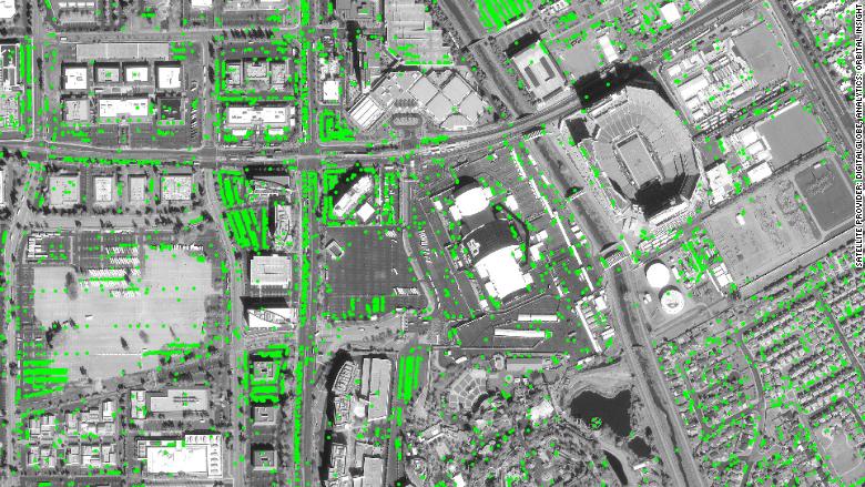
In a technique called “parking lot fill rate analysis,” remote-sensing metrics companies combine artificial intelligence with satellite imagery of parking lots to predict revenue for hedge funds and Wall Street analysts. By pinpointing the exact location of the stores’ entrances and counting the cars month in and month out, analysts are able to get a fix on a company’s customer flow and shopping habits. From there, they can apply a mathematical regression to forecast the company’s expected sales before official statistics are released.
Orbital Insight, currently the most prominent geospatial analytics company, officially monitors the parking lots of more than 200,000 individual store locations for more than 100 different chains across all industries, including food, automotive and retail. These include the Cheesecake Factory, Chuck E. Cheese, Gap, Office Depot, O’Reilly Auto Parts, and The Container Store. So the next time you drive out to run errands, you may be helping an investment firm decide whether to put its financing behind Walmart, for example, or its competitor, Target.
Private Property
Satellite imagery has also become a tool for cash-hungry governments. The town of Riverhead on Long Island, NY used Google Earth to search backyards for illegal swimming pools. They found about 250 pools built without permits and collected $75,000 in fines. Surprised? The same happened in Greece. Faced with a budget crunch, Greece’s government used Google Earth to hunt for swimming pools, giving officials a justification for collecting extra taxes.
These cases may be setting a dangerous precedent for future surveillance strategies. If it is permissible for municipal officials to peek into every backyard in Riverhead, what is stopping other government agencies from spying on citizens’ private properties for their checklist of potential violations?

Legal gray area
The Fourth Amendment states “The right of the people to be secure in their persons, houses, papers, and effects, against unreasonable searches and seizures” and the need for probable cause if government officials want to search your property. Along the same line, any unlawful entry onto private property would be considered criminal trespassing. But somehow, the silent and faceless monitoring from above has been excused, or plainly disregarded, from these constitutional rights.
The argument for the legality of satellite imagery is that it cooperates with all on equal terms—it does not change its story based on the inquirer. The fact that satellites continually orbit the globe, collecting data indiscriminately, implies that any images taken and stored in a routine sweep might not necessarily be classed as directed surveillance. If an interested party, like an enforcement agency or Wall Street hedge fund, specifically tasked a satellite provider to perform targeted surveillance and the satellite was purposely moved to collect an image, that might be different.
This issue brings up the question of intent—but whether it is in the collection phase or processing phase, a line needs to be drawn on what constitutes an invasion of privacy. A.F. Westin in Privacy and Freedom (1967) defined privacy as “the claim of individuals … to determine for themselves when, how, and to what extent information about them is communicated to others.” Our personal information is not a commodity to be bought and sold—at the very least, not without our knowledge and consent. As with most Big Data collection and use, regulation needs to keep up with the pace of technology and recognize the collateral impact that it has on our privacy. It is going to be a major task to balance the opportunities of Earth-observing technologies against the rights of citizens, but protections need to be set in place before something unimaginable happens, or worse, this behavior is normalized.
References
Mike Elgan. “Big Brother is searching you.” Computerworld. 21 August 2010.
Ann M. Florini & Yahya Dehqanzada. “Commercial Satellite Imagery Comes of Age.” Issues in Science and Technology. Fall 1999.
Kate Baucherel. “High-resolution satellites: are our privacy expectations too high?” Center for Digital Ethics & Policy. 29 April 2015.
Eamon Jeavers. “New Big Brother: Market-Moving Satellite Images.” CNBC. 16 August 2010.
Valery Komissarov. “AI Applications for Satellite Imagery and Satellite Data.” Tech Emergence. 2017 September 10.
Ray Purdy. “Ruling on sharper satellite images poses a privacy problem we can no longer ignore.” The Conversation. 18 June 2014.
Neal Ungerleider. “Google Earth, Foreign Wars, And The Future Of Satellite Imagery.” Fast Company. 29 November 2011.
Jeffrey Bellin & Andrew Guthrie Ferguson. “Trial By Google: Judicial Notice in the Information Age.” Northwestern Law Review. 2014.